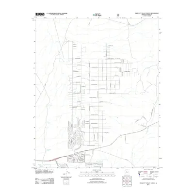
2012 Map of Prescott Valley North
USGS Topo · Published 2012About this map
The Agua Fria River winds through the southern landscape of this 2012 Prescott Valley quadrangle, anchoring a region defined by modern residential expansion and traditional ranching roots. The map reveals an intricate grid of newer thoroughfares such as E Pronghorn Ranch Pkwy and E Park View Dr, which contrast with the expansive ranchlands of the north. Water management is central to the area's utility, evidenced by several strategically placed tanks like Black Hill Tank, Midway Tank, and Highway Tank. The eastern edge is marked by the seasonal drainage of Coyote Wash. This survey captures a specific era of suburban growth in Yavapai County, where desert terrain meets planned development along routes like E Lonesome Valley Rd.
Find a feature on this map
104 named features on this map. Tap any name to fly to it.
Don’t see what you’re looking for? This feature index may not catch every label — zoom into the map to look around manually.
Map Details
Editions of this 2012 Prescott Valley North Map
This is the sole edition of this map. No revisions or reprints were ever made.
Other maps of this area

1887 · Prescott
USGS Topo · 1:250,000

1892 · Prescott
USGS Topo · 1:250,000

1905 · Jerome
USGS Topo · 1:125,000

1944 · Clarkdale
USGS Topo · 1:48,000

1944 · Mingus Mountain
USGS Topo · 1:62,500

1947 · Mingus Mtn
USGS Topo · 1:62,500

1947 · Paulden
USGS Topo · 1:62,500

1947 · Prescott
USGS Topo · 1:62,500

1948 · Prescott
USGS Topo · 1:62,500
1948 · Clarkdale
USGS Topo · 1:62,500