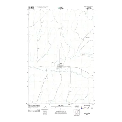
2011 Map of Prescott
USGS Topo · Published 2011About this map
Prescott serves as the central hub of this agricultural landscape in Walla Walla County, where the valley floor meets the undulating Skyrocket Hills. The town's grid is anchored by Railroad Ave, reflecting its historical reliance on rail transport for moving wheat and produce through the region. The Touchet River meanders across the southern portion of the quadrangle, joined by the smaller Whetstone Creek near the town center. This intersection of water and transport supports the smaller settlements of Robinson and McCall to the east. The surrounding terrain is defined by deep drainage systems such as Piper Canyon, Whetstone Hollow, and Colville Springs Hollow, which carve into the highlands. Local genealogy and history are preserved at the Ivy Cemetery, situated on the northern edge of the creek. The map details an extensive network of rural roads, including Brown Rd and Hart Rd, that connect these isolated agricultural pockets.
Find a feature on this map
20 named features on this map. Tap any name to fly to it.
Don’t see what you’re looking for? This feature index may not catch every label — zoom into the map to look around manually.
Map Details
Editions of this 2011 Prescott Map
This is the sole edition of this map. No revisions or reprints were ever made.
Other maps of this area

1919 · Walla Walla
USGS Topo · 1:125,000

1921 · Walla Walla
USGS Topo · 1:125,000

1953 · Walla Walla
USGS Topo · 1:250,000

1958 · Walla Walla
USGS Topo · 1:250,000

1966 · Dixie
USGS Topo · 1:24,000

1966 · Hadley
USGS Topo · 1:24,000

1966 · Valley Grove
USGS Topo · 1:24,000
1967 · Prescott
USGS Topo · 1:24,000

1967 · Waitsburg NW
USGS Topo · 1:24,000
1967 · Waitsburg
USGS Topo · 1:24,000