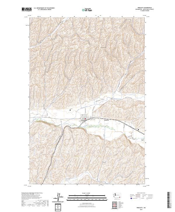
2023 Map of Prescott
USGS Topo · Published 2023About this map
Prescott lies at the heart of this landscape, situated at the confluence of the agricultural valleys and rolling uplands of Walla Walla County. The town is flanked by the Touchet River to the south and Whetstone Creek to the north, which flows through Whetstone Hollow. This topography defines the local settlement pattern, with residences and infrastructure clustered near the water and rail routes while the surrounding Skyrocket Hills and Touchet Valley are dominated by large-scale farming and winding county roads. For those researching local history or genealogy, the map identifies specific family-named landmarks and burial sites, including Ivy Cem just north of the town center and Foster Cem situated further east near the settlement of Robinson. The network of roads such as Lyons Ferry Rd and Skyrocket Rd provides a detailed view of the connectivity between these rural outposts and the primary thoroughfares.
Find a feature on this map
27 named features on this map. Tap any name to fly to it.
Don’t see what you’re looking for? This feature index may not catch every label — zoom into the map to look around manually.
Map Details
Editions of this 2023 Prescott Map
This is the sole edition of this map. No revisions or reprints were ever made.
Other maps of this area

1919 · Walla Walla
USGS Topo · 1:125,000

1921 · Walla Walla
USGS Topo · 1:125,000

1953 · Walla Walla
USGS Topo · 1:250,000

1958 · Walla Walla
USGS Topo · 1:250,000

1966 · Dixie
USGS Topo · 1:24,000

1966 · Hadley
USGS Topo · 1:24,000

1966 · Valley Grove
USGS Topo · 1:24,000
1967 · Prescott
USGS Topo · 1:24,000

1967 · Waitsburg NW
USGS Topo · 1:24,000
1967 · Waitsburg
USGS Topo · 1:24,000