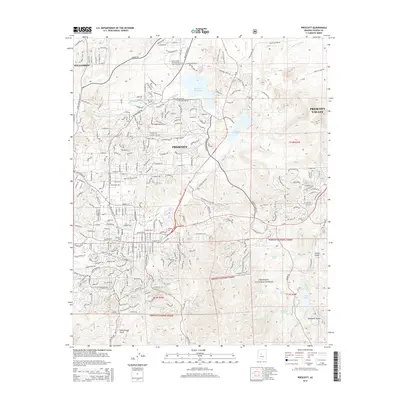
2014 Map of Prescott
USGS Topo · Published 2014About this map
Prescott sits at the heart of this 2014 survey, illustrating the modern footprint of Arizona's territorial capital against the edges of the Prescott National Forest. The map documents a sophisticated educational and civic landscape, featuring the sprawling campuses of Embry Riddle Aeronautical University-Prescott, Yavapai Coll, and Prescott Coll. To the north and east, the expansion toward Williamson and Prescott Valley is visible, linked by the corridor of State Hwy 89. The region's critical water management is evident in the reservoirs of Watson Lake, Willow Cr Reservoir, and Lynx Lake, which punctuate the high-desert terrain. To the west, the prominent landmark of Thumb Butte stands over the city, while the southern reaches transition into the more secluded drainage of Schoolhouse Gulch.
Find a feature on this map
44 named features on this map. Tap any name to fly to it.
Don’t see what you’re looking for? This feature index may not catch every label — zoom into the map to look around manually.
Map Details
Editions of this 2014 Prescott Map
This is the sole edition of this map. No revisions or reprints were ever made.
Other maps of this area

1887 · Prescott
USGS Topo · 1:250,000

1892 · Prescott
USGS Topo · 1:250,000

1903 · Bradshaw Mountains
USGS Topo · 1:125,000

1903 · Congress
USGS Topo · 1:125,000

1904 · Congress
USGS Topo · 1:125,000

1905 · Jerome
USGS Topo · 1:125,000

1947 · Iron Springs
USGS Topo · 1:62,500

1947 · Mt. Union
USGS Topo · 1:62,500

1947 · Kirkland
USGS Topo · 1:62,500

1947 · Prescott
USGS Topo · 1:62,500