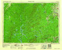
1960 Map of Presque Isle
USGS Topo · Published 1960About this map
Aroostook County and its neighbors in Northern Maine are defined here by a transition from the agricultural and timber hubs of the east to the deep wilderness of the northern woods. The map showcases a landscape of interconnected waterways, where the Allagash River flows past Allagash Falls and the Allagash Mountain range. To the south, the protected lands of Baxter State Park contain peaks like Mount Chase and Traveler Mountain, while the eastern border with Canada is dotted with established settlements such as Washburn, Mapleton, and the regional center of Presque Isle.
Find a feature on this map
173 named features on this map. Tap any name to fly to it.
Don’t see what you’re looking for? This feature index may not catch every label — zoom into the map to look around manually.
Map Details
Editions of this 1960 Presque Isle Map
3 editions found

Other maps of this area

1921 · Van Buren
USGS Topo · 1:250,000

1927 · Stockholm
USGS Topo · 1:48,000

1927 · Katahdin
USGS Topo · 1:48,000

1927 · Square Lake
USGS Topo · 1:48,000

1928 · Eagle Lake
USGS Topo · 1:48,000

1928 · Winterville
USGS Topo · 1:48,000

1929 · Portage
USGS Topo · 1:62,500

1929 · Caribou
USGS Topo · 1:48,000

1930 · Katahdin
USGS Topo · 1:62,500

1930 · Greenlaw
USGS Topo · 1:48,000