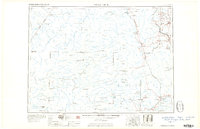
1960 Map of Presque Isle
USGS Topo · Published 1960About this map
Presque Isle and the vast timberlands of northern Maine are documented here during the mid-century, a time when the region's economy relied heavily on the Bangor and Aroostook railroad. The map shows the sprawling wilderness of the Maine North Woods, including the remote headwaters of the Allagash River and the high peaks of Baxter State Park, anchored by Mount Katahdin. This era represents the height of the Cold War presence at Presque Isle AFB, which stands in contrast to the rural agricultural and logging settlements like Washburn, Ashland, and Smyrna Mills. To the west, the international border with Canada is clearly defined, separating the Maine wilderness from Quebec settlements such as St Pamphile. The landscape is a network of remote ponds and ridges, from Caucomgomoc Lake to Norway Bluff, reachable then primarily by rail or primitive woods roads.
Find a feature on this map
253 named features on this map. Tap any name to fly to it.
Don’t see what you’re looking for? This feature index may not catch every label — zoom into the map to look around manually.
Map Details
Editions of this 1960 Presque Isle Map
3 editions found

Other maps of this area

1921 · Van Buren
USGS Topo · 1:250,000

1927 · Stockholm
USGS Topo · 1:48,000

1927 · Katahdin
USGS Topo · 1:48,000

1927 · Square Lake
USGS Topo · 1:48,000

1928 · Eagle Lake
USGS Topo · 1:48,000

1928 · Winterville
USGS Topo · 1:48,000

1929 · Portage
USGS Topo · 1:62,500

1929 · Caribou
USGS Topo · 1:48,000

1930 · Katahdin
USGS Topo · 1:62,500

1930 · Greenlaw
USGS Topo · 1:48,000