
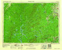
1960 Map of Presque Isle
USGS Topo · Published 1960About this map
Presque Isle serves as the focal point of this northern Maine survey, which encompasses the vast timberlands and river systems of the mid-twentieth century. The landscape is defined by the extensive operations of the Bangor and Aroostook railroad, which connected remote logging outposts and agricultural centers like Washburn and Ashland to the broader regional economy. Notable for the era, the presence of Presque Isle AFB highlights the strategic importance of this border region during the Cold War.
Find a feature on this map
151 named features on this map. Tap any name to fly to it.
Don’t see what you’re looking for? This feature index may not catch every label — zoom into the map to look around manually.
Map Details
Editions of this 1960 Presque Isle Map
3 editions found
Other maps of this area

1921 · Van Buren
USGS Topo · 1:250,000

1927 · Stockholm
USGS Topo · 1:48,000

1927 · Katahdin
USGS Topo · 1:48,000

1927 · Square Lake
USGS Topo · 1:48,000

1928 · Eagle Lake
USGS Topo · 1:48,000

1928 · Winterville
USGS Topo · 1:48,000

1929 · Portage
USGS Topo · 1:62,500

1929 · Caribou
USGS Topo · 1:48,000

1930 · Katahdin
USGS Topo · 1:62,500

1930 · Greenlaw
USGS Topo · 1:48,000