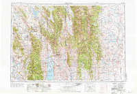
1955 Map of Preston
USGS Topo · Published 1976About this map
Bear Lake sits at the southern edge of this mid-century survey, anchoring a region defined by the high ranges of the Rocky Mountains and the expansive Green River Basin. The landscape is a complex network of public lands, including the Cache, Caribou, and Bridger National Forests, which surround agricultural corridors and river valleys. The Bear River winds through the western half of the map, supporting a string of communities like Preston and Montpelier that developed along the Union Pacific rail lines.
Find a feature on this map
132 named features on this map. Tap any name to fly to it.
Don’t see what you’re looking for? This feature index may not catch every label — zoom into the map to look around manually.
Map Details
Editions of this 1955 Preston Map
3 editions found

Other maps of this area

1907 · Gros Ventre
USGS Topo · 1:125,000

1909 · Fremont Peak
USGS Topo · 1:125,000

1909 · Montpelier
USGS Topo · 1:125,000

1910 · Gros Ventre
USGS Topo · 1:125,000

1911 · Montpelier
USGS Topo · 1:125,000

1911 · Slug Creek
USGS Topo · 1:62,500

1912 · Randolph
USGS Topo · 1:125,000

1914 · Henry
USGS Topo · 1:48,000

1914 · Logan
USGS Topo · 1:125,000

1915 · Preston
USGS Topo · 1:96,000