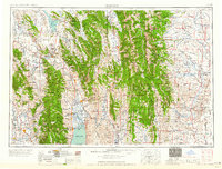
1958 Map of Preston
USGS Topo · Published 1958About this map
Caribou National Forest and Bridger National Forest dominate this mid-century topographic view of the High Rockies borderland. The terrain is defined by the sharp verticality of the Salt River Range and Wyoming Range, which guide the path of the Bear River as it loops through Idaho and Wyoming. Near the southern edge, the expansive waters of Bear Lake sit between the Bear Lake Plateau and the agricultural valley settlements of St. Charles, Bloomington, and Paris. The Union Pacific rail line and U.S. 30n serve as the primary conduits for commerce and transit, connecting Soda Springs and Montpelier to the broader regional network. To the east, the Green River valley shows early development near the Fontenelle Reservoir, reflecting the post-war era's focus on water management and resource infrastructure.
Find a feature on this map
38 named features on this map. Tap any name to fly to it.
Don’t see what you’re looking for? This feature index may not catch every label — zoom into the map to look around manually.
Map Details
Editions of this 1958 Preston Map
2 editions found

Other maps of this area

1907 · Gros Ventre
USGS Topo · 1:125,000

1909 · Fremont Peak
USGS Topo · 1:125,000

1909 · Montpelier
USGS Topo · 1:125,000

1910 · Gros Ventre
USGS Topo · 1:125,000

1911 · Montpelier
USGS Topo · 1:125,000

1911 · Slug Creek
USGS Topo · 1:62,500

1912 · Randolph
USGS Topo · 1:125,000

1914 · Henry
USGS Topo · 1:48,000

1914 · Logan
USGS Topo · 1:125,000

1915 · Preston
USGS Topo · 1:96,000