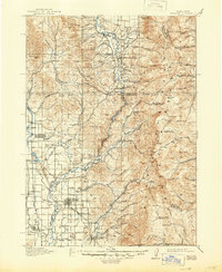
1918 Map of Preston
USGS Topo · Published 1946About this map
Gentile Valley and the Bear River corridor serve as the agricultural heart of this 1915 survey. The landscape is defined by an intricate network of irrigation systems, including the Oneida Canal, Preston Canal, and West Canal, which supported the early development of Preston, Franklin, and Weston. These engineering efforts transformed the arid benches of Poverty Flats and the basins around the Cub River into productive farmsteads. The industrial footprint of the era is visible through the Power Plant on the Bear River and the infrastructure of the Oregon Short Line railroad.
Find a feature on this map
119 named features on this map. Tap any name to fly to it.
Don’t see what you’re looking for? This feature index may not catch every label — zoom into the map to look around manually.
Map Details
Editions of this 1918 Preston Map
2 editions found
Other maps of this area

1909 · Montpelier
USGS Topo · 1:125,000

1911 · Montpelier
USGS Topo · 1:125,000

1911 · Slug Creek
USGS Topo · 1:62,500

1912 · Randolph
USGS Topo · 1:125,000

1914 · Logan
USGS Topo · 1:125,000

1915 · Preston
USGS Topo · 1:96,000

1916 · Logan
USGS Topo · 1:125,000

1918 · Preston
USGS Topo · 1:125,000

1948 · Bancroft
USGS Topo · 1:62,500

1948 · Soda Springs
USGS Topo · 1:62,500