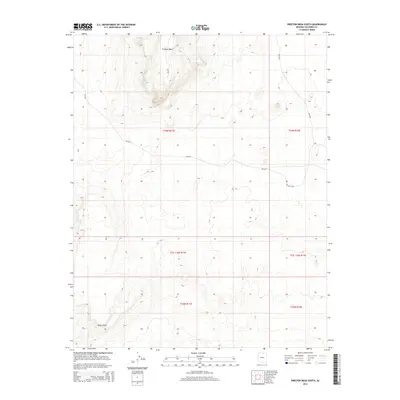
2014 Map of Preston Mesa South
USGS Topo · Published 2014About this map
Preston Mesa dominates the northern landscape of this Coconino County terrain, standing as a prominent geological landmark in this high-desert environment. The 2014 survey documents a network of Bureau of Indian Affairs routes, including Bia-6231 and Bia-6230, which provide the primary access through these vast township blocks. To the southwest, the rise of White Cliff provides a distinct topographical contrast, anchoring the lower portion of the map. This area is characterized by its organized Bureau of Land Management surveying, with section lines and township markers like t34n r11e and t33n r12e defining the administrative boundaries of the land. The presence of Bia-6231-Loop suggests localized transit patterns and access points within the open range, offering a detailed look at the infrastructure serving this part of the Arizona interior during the early 21st century.
Find a feature on this map
12 named features on this map. Tap any name to fly to it.
Don’t see what you’re looking for? This feature index may not catch every label — zoom into the map to look around manually.
Map Details
Editions of this 2014 Preston Mesa South Map
This is the sole edition of this map. No revisions or reprints were ever made.
Other maps of this area

1886 · Echo Cliffs
USGS Topo · 1:250,000

1891 · Echo Cliffs
USGS Topo · 1:250,000

1956 · Marble Canyon
USGS Topo · 1:250,000

1959 · Marble Canyon
USGS Topo · 1:250,000

1961 · Marble Canyon
USGS Topo · 1:250,000
1969 · Tuba City NE
USGS Topo · 1:24,000
1969 · Tuba City
USGS Topo · 1:24,000
1969 · Moenave
USGS Topo · 1:24,000
1981 · Big Whisker Well
USGS Topo · 1:24,000
1982 · Gopher Spring
USGS Topo · 1:24,000