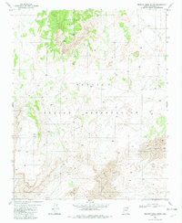
1982 Map of Preston Mesa South
USGS Topo · Published 1982About this map
Navajo Indian Reservation lands in Coconino County define this 1982 topographic study, dominated by the prominent plateau of Preston Mesa in the north and the shifting landscape of Sand Dunes to the south. The high desert environment is marked by sparse but critical infrastructure, including multiple locations of a Corral and a functional Guzzler, pointing to a geography shaped by livestock management and water conservation in an arid climate. To the southwest, the terrain rises toward White Point, while the presence of a Radio Facility on the mesa indicates the intersection of traditional land use with modern communications. The map meticulously records the 4WD tracks and trails that served as the primary transit network through this portion of the reservation during the late 1970s and early 1980s.
Find a feature on this map
8 named features on this map. Tap any name to fly to it.
Don’t see what you’re looking for? This feature index may not catch every label — zoom into the map to look around manually.
Map Details
Editions of this 1982 Preston Mesa South Map
This is the sole edition of this map. No revisions or reprints were ever made.
Other maps of this area

1886 · Echo Cliffs
USGS Topo · 1:250,000

1891 · Echo Cliffs
USGS Topo · 1:250,000

1956 · Marble Canyon
USGS Topo · 1:250,000

1959 · Marble Canyon
USGS Topo · 1:250,000

1961 · Marble Canyon
USGS Topo · 1:250,000
1969 · Tuba City NE
USGS Topo · 1:24,000
1969 · Tuba City
USGS Topo · 1:24,000
1969 · Moenave
USGS Topo · 1:24,000
1981 · Big Whisker Well
USGS Topo · 1:24,000
1982 · Gopher Spring
USGS Topo · 1:24,000