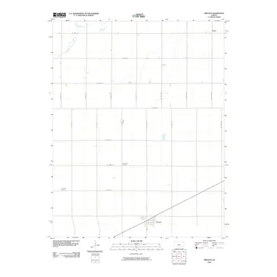
2009 Map of Preston
USGS Topo · Published 2009About this map
The town of Preston serves as the primary hub in this portion of Pratt County, defined by its traditional grid centered on Main St. The surrounding landscape is characterized by a precise system of section-line roads, including NE 100th St and SE 70th Ave, reflecting the enduring agricultural layout of the High Plains. Natural drainage is shaped by the North Fork Ninnescah River, which meanders across the northwestern corner of the quadrangle. Smaller rural points of interest like Neola and the quiet presence of the Haynesville Cemetery and Friendship Cemetery provide essential markers for genealogists and local historians tracing family ties and vanished homesteads in this region. The map captures the area in a state of late-twentieth-century stability, where modern transportation corridors follow the same paths established by early settlers.
Find a feature on this map
26 named features on this map. Tap any name to fly to it.
Don’t see what you’re looking for? This feature index may not catch every label — zoom into the map to look around manually.
Map Details
Editions of this 2009 Preston Map
This is the sole edition of this map. No revisions or reprints were ever made.
Other maps of this area

1892 · Kingman
USGS Topo · 1:125,000

1892 · Pratt
USGS Topo · 1:125,000

1894 · Kingman
USGS Topo · 1:125,000

1894 · Pratt
USGS Topo · 1:125,000

1955 · Pratt
USGS Topo · 1:250,000

1959 · Pratt
USGS Topo · 1:250,000

1966 · Cunningham
USGS Topo · 1:24,000

1967 · Cairo
USGS Topo · 1:24,000

1968 · Pratt
USGS Topo · 1:24,000
1971 · Turon
USGS Topo · 1:24,000