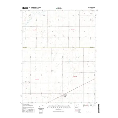
2015 Map of Preston
USGS Topo · Published 2015About this map
Preston serves as the primary population center in this rural stretch of South Central Kansas, situated where the high plains transition toward the drainage of the N Fork Ninnescah River. The town's grid is clearly defined by streets such as Thomas St and Cogswell St, reflecting its role as a local agricultural hub. Further north, the settlement of Neola sits near the Stafford County line, marking the northern extent of this surveyed area. The landscape is defined by its watercourses, including the meandering path of Silver Cr south of Preston. For those researching local heritage, the map identifies key burial sites like Haynesville Cem and Friendship Cem, which provide tangible links to the families who established the farming communities across this region.
Find a feature on this map
25 named features on this map. Tap any name to fly to it.
Don’t see what you’re looking for? This feature index may not catch every label — zoom into the map to look around manually.
Map Details
Editions of this 2015 Preston Map
This is the sole edition of this map. No revisions or reprints were ever made.
Other maps of this area

1892 · Kingman
USGS Topo · 1:125,000

1892 · Pratt
USGS Topo · 1:125,000

1894 · Kingman
USGS Topo · 1:125,000

1894 · Pratt
USGS Topo · 1:125,000

1955 · Pratt
USGS Topo · 1:250,000

1959 · Pratt
USGS Topo · 1:250,000

1966 · Cunningham
USGS Topo · 1:24,000

1967 · Cairo
USGS Topo · 1:24,000

1968 · Pratt
USGS Topo · 1:24,000
1971 · Turon
USGS Topo · 1:24,000