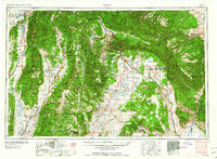
1960 Map of Price
USGS Topo · Published 1960About this map
Price sits at the heart of this mid-century portrait of Central Utah, serving as a hub for the mining and ranching districts of Carbon County. The Denver and Rio Grande Western RR cuts through the high desert, connecting industrial outposts like Helper and Sunnyside to the broader Western rail network. To the west, the Wasatch Plateau divides the landscape, dropping into the fertile San Pete Valley where established agricultural settlements like Manti, Ephraim, and Mount Pleasant thrive along the San Pitch River. This survey captures the region's complex water management system, documented through numerous irrigation projects such as the Cleveland Canal, Wellington Canal, and the Scofield Reservoir. From the heights of Mount Nebo to the geological expanse of the San Rafael Swell, the map details a transition from dense timber in the Manti-La Sal National Forest to the arid mesas approaching the Green River.
Find a feature on this map
227 named features on this map. Tap any name to fly to it.
Don’t see what you’re looking for? This feature index may not catch every label — zoom into the map to look around manually.
Map Details
Editions of this 1960 Price Map
2 editions found

Other maps of this area

1885 · San Rafael
USGS Topo · 1:250,000

1885 · Salt Lake
USGS Topo · 1:250,000

1885 · Manti
USGS Topo · 1:250,000

1885 · East Tavaputs
USGS Topo · 1:250,000

1885 · La Sal
USGS Topo · 1:250,000

1885 · Beaver
USGS Topo · 1:250,000

1885 · Ashley
USGS Topo · 1:250,000

1885 · Sevier Desert
USGS Topo · 1:250,000

1885 · Fish Lake
USGS Topo · 1:250,000

1885 · Uinta
USGS Topo · 1:250,000