
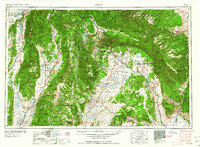
1960 Map of Price
USGS Topo · Published 1960About this map
Price and the surrounding coal mining districts of the Wasatch Plateau define this mid-century look at central Utah. The industrial backbone of the region is visible in the network of the Denver and Rio Grande Western and Utah Ry, which served established company towns like Hiawatha and Sunnyside. To the east, the Tavaputs Plateau and Book Cliffs create a sharp geographic boundary, while the western portion of the map covers the agricultural corridors of the San Pete Valley and Juab Valley.
Find a feature on this map
128 named features on this map. Tap any name to fly to it.
Don’t see what you’re looking for? This feature index may not catch every label — zoom into the map to look around manually.
Map Details
Editions of this 1960 Price Map
2 editions found
Other maps of this area

1885 · San Rafael
USGS Topo · 1:250,000

1885 · Salt Lake
USGS Topo · 1:250,000

1885 · Manti
USGS Topo · 1:250,000

1885 · East Tavaputs
USGS Topo · 1:250,000

1885 · La Sal
USGS Topo · 1:250,000

1885 · Beaver
USGS Topo · 1:250,000

1885 · Ashley
USGS Topo · 1:250,000

1885 · Sevier Desert
USGS Topo · 1:250,000

1885 · Fish Lake
USGS Topo · 1:250,000

1885 · Uinta
USGS Topo · 1:250,000