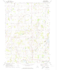
1972 Map of Price
USGS Topo · Published 1974About this map
Sleepy Hollow State Park dominates the eastern half of this Clinton County landscape, where the Little Maple River flows through a series of natural basins. The early 1970s environment is characterized by a high density of rural cemeteries and family-named landmarks, reflecting the deep agricultural roots of Ovid and Victor townships. Local transit is defined by a network of sectional roads such as Price Road and Pratt Road, while the southern edge is clipped by the Penn Central railroad and the Looking Glass River. Scattered lakes like Lake Victoria and Richmond Lake provide natural focal points amidst the surveyed grid. Small aviation sites, including Archer Landing Field and Dennis Farms Landing Field, highlight the era's reliance on private airstrips for local transport and agricultural utility.
Find a feature on this map
49 named features on this map. Tap any name to fly to it.
Don’t see what you’re looking for? This feature index may not catch every label — zoom into the map to look around manually.
Map Details
Editions of this 1972 Price Map
2 editions found
Other maps of this area

1918 · Elsie
USGS Topo · 1:62,500

1918 · Perrinton
USGS Topo · 1:62,500

1927 · De Witt
USGS Topo · 1:62,500

1928 · Laingsburg
USGS Topo · 1:62,500

1943 · Perrinton
USGS Topo · 1:62,500

1943 · Elsie
USGS Topo · 1:62,500

1944 · Laingsburg
USGS Topo · 1:62,500

1954 · Midland
USGS Topo · 1:250,000

1958 · Midland
USGS Topo · 1:250,000

1958 · Grand Rapids
USGS Topo · 1:250,000