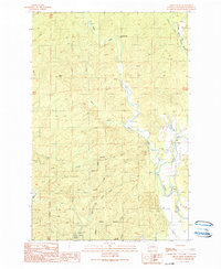
1990 Map of Prices Peak
USGS Topo · Published 1990About this map
West Fork Satsop River and its sister forks converge in this timbered region of Grays Harbor County, creating a complex drainage system defined by the confluence of the Middle Fork and East Fork Satsop River. The southern portion of the landscape transitions toward the Montesano Corporate Boundary, where recreation and utility meet at Lake Sylvia State Park. The impoundment of Sylvia Lake provides a focal point for the surrounding area, which is otherwise dominated by the ascent toward Prices Peak. Detailed topographic markings reveal a history of local access and small-scale industry, indicated by several Gravel Pit locations and multiple crossings such as a Swinging Bridge and dedicated Footbridge sites. This 1990 provisional edition documents the precise hydrological and topographic character of the Satsop river system before modern development or forest management shifts.
Find a feature on this map
19 named features on this map. Tap any name to fly to it.
Don’t see what you’re looking for? This feature index may not catch every label — zoom into the map to look around manually.
Map Details
Editions of this 1990 Prices Peak Map
This is the sole edition of this map. No revisions or reprints were ever made.
Other maps of this area

1940 · Montesano
USGS Topo · 1:62,500

1941 · Mobray
USGS Topo · 1:62,500

1941 · Ford
USGS Topo · 1:62,500

1943 · Nahwatzel Lake
USGS Topo · 1:62,500

1943 · Mobray
USGS Topo · 1:62,500

1953 · Hoquiam
USGS Topo · 1:250,000

1953 · Malone
USGS Topo · 1:62,500

1953 · Elma
USGS Topo · 1:62,500

1955 · Montesano
USGS Topo · 1:62,500

1955 · Wynoochee Valley
USGS Topo · 1:62,500