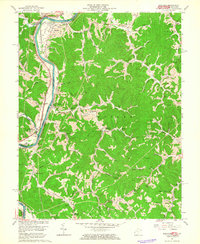
1962 Map of Prichard
USGS Topo · Published 1963About this map
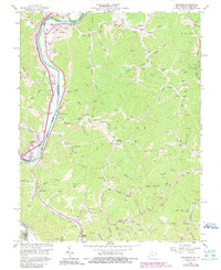
The Big Sandy River forms the central artery of this landscape, marking the winding border between Kentucky and West Virginia in the early 1960s. Along its banks, the Norfolk and Western and Chesapeake and Ohio railroads parallel the water, serving industrial points like the tipple at Prichard. The terrain is defined by deep hollows and narrow ridges, where small settlements such as Hubbardstown and Hurricane are tucked away.
Find a feature on this map
76 named features on this map. Tap any name to fly to it.
Don’t see what you’re looking for? This feature index may not catch every label — zoom into the map to look around manually.
Map Details
Editions of this 1962 Prichard Map
5 editions found
Other maps of this area

1892 · Huntington
USGS Topo · 1:125,000

1898 · Huntington
USGS Topo · 1:125,000

1901 · Guyandot
USGS Topo · 1:62,500

1901 · Ceredo
USGS Topo · 1:62,500

1902 · Guyandot
USGS Topo · 1:62,500

1903 · Kenova
USGS Topo · 1:125,000

1904 · Kenova
USGS Topo · 1:125,000

1909 · Wayne
USGS Topo · 1:62,500

1911 · Louisa
USGS Topo · 1:48,000

1913 · Ceredo
USGS Topo · 1:62,500