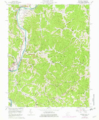
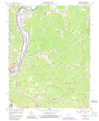
1962 Map of Prichard
USGS Topo · Published 1976About this map
The Big Sandy River forms a winding border between Kentucky and West Virginia, anchoring a landscape of deep hollows and ridgelines in the mid-20th century. Parallel transportation routes, the Norfolk and Western and Chesapeake and Ohio railroads, track the river's path, serving industrial sites like the coal tipple near Prichard. Small settlements such as Buchanan and Hubbardstown are tucked into the narrow valleys, while the surrounding hills are marked by numerous family cemeteries including Hatton Cem and Lakin Cem. The prevalence of gas wells and oil wells scattered throughout the Butler and Union districts points to a landscape defined by resource extraction. Local social life is evidenced by country landmarks like the Brick Church and Smith Sch, alongside community spaces like Ridge Memorial Hall.
Find a feature on this map
92 named features on this map. Tap any name to fly to it.
Don’t see what you’re looking for? This feature index may not catch every label — zoom into the map to look around manually.
Map Details
Editions of this 1962 Prichard Map
5 editions found
Other maps of this area

1892 · Huntington
USGS Topo · 1:125,000

1898 · Huntington
USGS Topo · 1:125,000

1901 · Guyandot
USGS Topo · 1:62,500

1901 · Ceredo
USGS Topo · 1:62,500

1902 · Guyandot
USGS Topo · 1:62,500

1903 · Kenova
USGS Topo · 1:125,000

1904 · Kenova
USGS Topo · 1:125,000

1909 · Wayne
USGS Topo · 1:62,500

1911 · Louisa
USGS Topo · 1:48,000

1913 · Ceredo
USGS Topo · 1:62,500