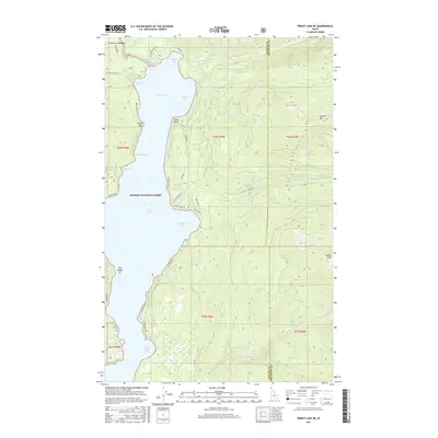
2017 Map of Priest Lake NE
USGS Topo · Published 2017About this map
Priest Lake dominates the central landscape of this northern Idaho survey, where the water is punctuated by Twin Islands and several prominent bays. The rugged shoreline within Kaniksu National Forest features distinctive landmarks such as Tripod Point and Canoe Point, while the northern reaches connect via The Thorofare toward Armstrong Meadows. The terrain rises sharply from the water's edge toward high peaks like Klootch Mtn and Goblin Knob, defining a landscape where access is primarily limited to forest roads like E Shore Rd and Lakeshore. This mapping shows the distribution of private development in coves like Huckleberry Bay and Bear Creek Bay, reflecting the seasonal and recreational use of the forest lands. Numerous drainage systems including Lion Cr and Two Mouth Cr feed the lake, highlighting the intricate watershed of the Idaho Panhandle.
Find a feature on this map
53 named features on this map. Tap any name to fly to it.
Don’t see what you’re looking for? This feature index may not catch every label — zoom into the map to look around manually.
Map Details
Editions of this 2017 Priest Lake NE Map
This is the sole edition of this map. No revisions or reprints were ever made.
Other maps of this area

1911 · Priest Lake
USGS Topo · 1:250,000

1913 · Priest Lake
USGS Topo · 1:250,000

1958 · Sandpoint
USGS Topo · 1:250,000

1963 · Sandpoint
USGS Topo · 1:250,000

1967 · Priest Lake SE
USGS Topo · 1:24,000

1967 · Priest Lake NE
USGS Topo · 1:24,000

1967 · Priest Lake NW
USGS Topo · 1:24,000

1967 · The Wigwams
USGS Topo · 1:24,000

1967 · Mount Roothaan
USGS Topo · 1:24,000
1967 · Priest Lake SW
USGS Topo · 1:24,000