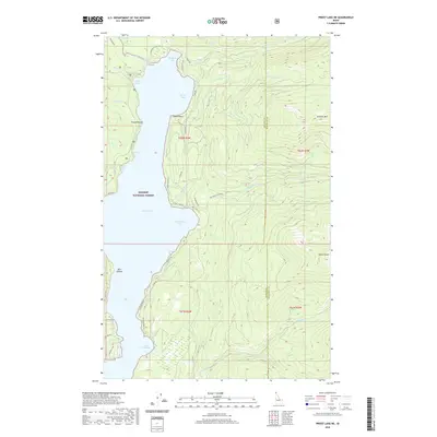
2020 Map of Priest Lake NE
USGS Topo · Published 2020About this map
Kaniksu National Forest defines the eastern shoreline of northern Priest Lake, where high-elevation peaks like Klootch Mtn and Goblin Knob overlook the water. The landscape is marked by a complex network of drainage systems, including the N Fork Squaw Cr and Two-Mouth Cr, which flow westward from the Bonner and Boundary County line. This 2020 topographic record shows a seasonal and recreation-focused geography, from the quiet waters of Huckleberry Bay to the narrow passage of The Thorofare at the northern reaches. Along the western edge, access is maintained via the Lakeshore Trail and local roads like Diamond Park Rd, serving small clusters of lakeside developments at Teachers Bay and Bottle Bay. The map captures the remote character of the Idaho Panhandle, where named terrain features like Tripod Point and Twin Islands provide navigational landmarks for both the lake and the surrounding timberland.
Find a feature on this map
53 named features on this map. Tap any name to fly to it.
Don’t see what you’re looking for? This feature index may not catch every label — zoom into the map to look around manually.
Map Details
Editions of this 2020 Priest Lake NE Map
This is the sole edition of this map. No revisions or reprints were ever made.
Other maps of this area

1911 · Priest Lake
USGS Topo · 1:250,000

1913 · Priest Lake
USGS Topo · 1:250,000

1958 · Sandpoint
USGS Topo · 1:250,000

1963 · Sandpoint
USGS Topo · 1:250,000

1967 · Priest Lake SE
USGS Topo · 1:24,000

1967 · Priest Lake NE
USGS Topo · 1:24,000

1967 · Priest Lake NW
USGS Topo · 1:24,000

1967 · The Wigwams
USGS Topo · 1:24,000

1967 · Mount Roothaan
USGS Topo · 1:24,000
1967 · Priest Lake SW
USGS Topo · 1:24,000