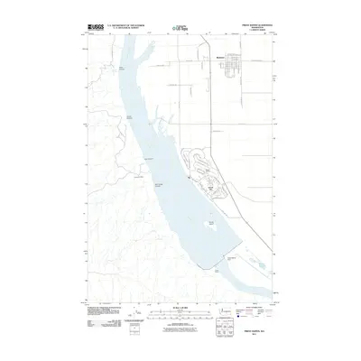
2011 Map of Priest Rapids
USGS Topo · Published 2011About this map
Mattawa and the planned community of Desert Aire occupy the eastern banks of the Columbia River in Grant County during this early 21st-century survey. The landscape is defined by the massive infrastructure of the Priest Rapids Dam and the turbulent waters of Priest Rapids just downstream. Residential development in Desert Aire is centered around the Desert Aire Airport and the shoreline, contrasted against the industrial activity at the Pozzuolana Mine to the west. On the opposite side of the river, the terrain is cut by several prominent coulees including Alkali Canyon, Corral Canyon, and Cow Canyon. These geological features lead down to the riverbanks near Goose Island, showing a region where intensive hydroelectric power generation and modern settlement meet the arid, dissected plateau of central Washington.
Find a feature on this map
55 named features on this map. Tap any name to fly to it.
Don’t see what you’re looking for? This feature index may not catch every label — zoom into the map to look around manually.
Map Details
Editions of this 2011 Priest Rapids Map
This is the sole edition of this map. No revisions or reprints were ever made.
Other maps of this area

1912 · Beverly
USGS Topo · 1:62,500

1917 · Priest Rapids
USGS Topo · 1:62,500

1936 · Hog Ranch Buttes
USGS Topo · 1:48,000

1939 · Boylston
USGS Topo · 1:48,000

1941 · Black Rock Spring
USGS Topo · 1:62,500

1943 · Boylston
USGS Topo · 1:62,500

1948 · Cairn Hope Peak
USGS Topo · 1:24,000

1948 · Emerson Nipple
USGS Topo · 1:24,000

1948 · Priest Rapids
USGS Topo · 1:24,000

1950 · Yakima
USGS Topo · 1:250,000