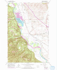
1963 Map of Primrose
USGS Topo · Published 1978About this map
The Clark Fork river carves through this valley west of Missoula, serving as a corridor for competing rail lines and early irrigation efforts during the 1960s and 1970s. The Chicago Milwaukee St Paul and Pacific and the Burlington Northern railroads parallel the river, supporting local industry at Schilling and the nearby Schilling Siding. The landscape is defined by the transition from the steep, timbered slopes of the Lolo National Forest to the productive lowlands of the Grass Valley French Ditch and Frenchtown Irrigation District Ditch.
Find a feature on this map
27 named features on this map. Tap any name to fly to it.
Don’t see what you’re looking for? This feature index may not catch every label — zoom into the map to look around manually.
Map Details
Editions of this 1963 Primrose Map
2 editions found
Other maps of this area

1912 · Missoula
USGS Topo · 1:125,000

1956 · Wallace
USGS Topo · 1:250,000

1956 · Hamilton
USGS Topo · 1:250,000

1959 · Hamilton
USGS Topo · 1:250,000

1959 · Alberton
USGS Topo · 1:62,500

1959 · Arlee
USGS Topo · 1:62,500

1960 · Wallace
USGS Topo · 1:250,000

1960 · Hamilton
USGS Topo · 1:250,000

1963 · Primrose
USGS Topo · 1:24,000

1964 · Hamilton
USGS Topo · 1:250,000