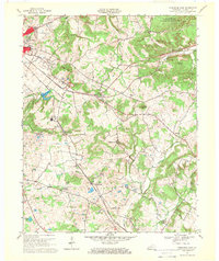
1967 Map of Princeton East
USGS Topo · Published 1969About this map
Princeton serves as the primary hub for this portion of Caldwell County, where the industrial presence of the Illinois Central railroad intersects with local agricultural research at the Univ of Kentucky Agricultural Experiment Substation. The landscape is a mix of small hamlets like Scottsburg and Friendship and conservation lands such as the Jones-Keeney Wildlife Management Area. Numerous family burial grounds, including Wadlington Cem, McConnell Cem, and Dance-Nichols Cem, are scattered across the terrain, offering vital clues for genealogical research. Water features such as Otter Pond, Railroad Lake, and Smith Lake provide distinct landmarks among the ridges, while the Princeton-Caldwell Airport and a local Drive-in Theater mark the mid-century infrastructure of the area.
Find a feature on this map
51 named features on this map. Tap any name to fly to it.
Don’t see what you’re looking for? This feature index may not catch every label — zoom into the map to look around manually.
Map Details
Editions of this 1967 Princeton East Map
This is the sole edition of this map. No revisions or reprints were ever made.
Other maps of this area

1908 · Princeton
USGS Topo · 1:62,500

1909 · Dawson Springs
USGS Topo · 1:48,000

1910 · Princeton
USGS Topo · 1:62,500

1911 · Dawson Springs
USGS Topo · 1:62,500

1953 · Gracey
USGS Topo · 1:24,000

1953 · Cobb
USGS Topo · 1:24,000

1953 · Dawson Springs SW
USGS Topo · 1:24,000
1953 · Lamasco
USGS Topo · 1:24,000

1954 · Evansville
USGS Topo · 1:250,000
1954 · Princeton West
USGS Topo · 1:24,000