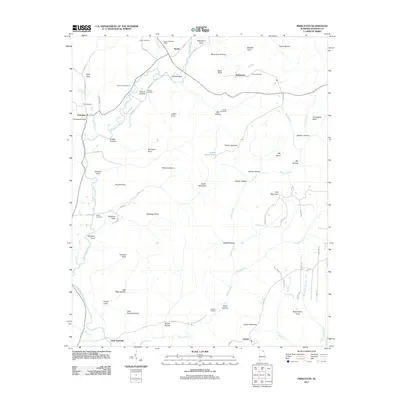
2011 Map of Princeton
USGS Topo · Published 2011About this map
Princeton serves as a central point in this northern Alabama landscape, situated where the Lick Fork meets the Paint Rock River. The topography is defined by a dense network of coves and hollows, such as Robertson Cove and Stovall Hollow, which have historically dictated the placement of small communities and family burial grounds. High points like Jacobs Mountain and Fork Mountain tower over the narrow valleys where roads like Co RD 9 follow the natural contours of the water.
Find a feature on this map
84 named features on this map. Tap any name to fly to it.
Don’t see what you’re looking for? This feature index may not catch every label — zoom into the map to look around manually.
Map Details
Editions of this 2011 Princeton Map
This is the sole edition of this map. No revisions or reprints were ever made.
Other maps of this area

1888 · Scottsboro
USGS Topo · 1:125,000

1892 · Scottsboro
USGS Topo · 1:125,000

1936 · Scottsboro
USGS Topo · 1:24,000

1936 · King Cove
USGS Topo · 1:24,000

1936 · Hollytree
USGS Topo · 1:24,000

1936 · Mud Creek
USGS Topo · 1:24,000

1936 · Hytop
USGS Topo · 1:24,000

1936 · Princeton
USGS Topo · 1:24,000

1936 · Lim Rock
USGS Topo · 1:24,000
1936 · Paint Rock
USGS Topo · 1:24,000