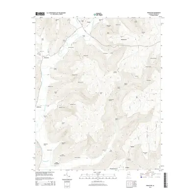
2014 Map of Princeton
USGS Topo · Published 2014About this map
Paint Rock River winds through this section of Jackson County, carving a valley floor that supports small communities like Princeton and Hollytree. The terrain is dominated by the dramatic rise of the Cumberland Plateau to the east, where the landscape is etched by numerous hollows and coves, such as Saltpeter Cove and Fowler Cove. For genealogists, the map is particularly detailed regarding burial sites, noting several family-named locations including Church Hill Cem, Graham Cem, and Latham Cem situated near the settlement of Skyline. The road network, including Al-65 and Al-146, follows the natural contours of the valley, connecting outlying locales like Swaim and Baileytown. Distinctive geological features like the Winding Stairs and Round Knob provide clear markers for the transition from the river bottom to the high plateau country.
Find a feature on this map
101 named features on this map. Tap any name to fly to it.
Don’t see what you’re looking for? This feature index may not catch every label — zoom into the map to look around manually.
Map Details
Editions of this 2014 Princeton Map
This is the sole edition of this map. No revisions or reprints were ever made.
Other maps of this area

1888 · Scottsboro
USGS Topo · 1:125,000

1892 · Scottsboro
USGS Topo · 1:125,000

1936 · Scottsboro
USGS Topo · 1:24,000

1936 · King Cove
USGS Topo · 1:24,000

1936 · Hollytree
USGS Topo · 1:24,000

1936 · Mud Creek
USGS Topo · 1:24,000

1936 · Hytop
USGS Topo · 1:24,000

1936 · Princeton
USGS Topo · 1:24,000

1936 · Lim Rock
USGS Topo · 1:24,000
1936 · Paint Rock
USGS Topo · 1:24,000