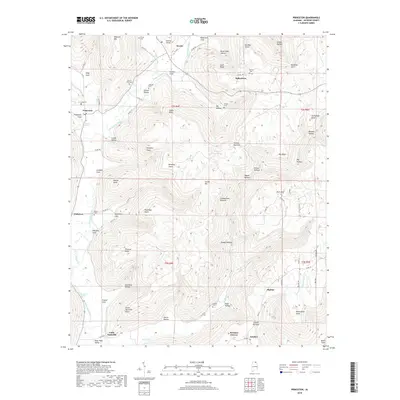
2018 Map of Princeton
USGS Topo · Published 2018About this map
Princeton and Hollytree anchor this survey of the Cumberland Plateau in northern Alabama, where the landscape is defined by the winding course of the Paint Rock River and its numerous tributaries like Lick Fork and Larkin Fork. The map reveals a high density of rural burial grounds, including Church Hill Cem, Clay Cem, and Rouse Cem, reflecting the deep-rooted settlement history of these secluded valleys and coves. The topography is exceptionally detailed, illustrating the sharp transitions from the river valley floors up to landmarks such as Maxwell Mtn, Jacobs Mtn, and the distinctive Winding Stairs. The transport network of county roads follows the natural contours of the terrain, connecting small communities like Skyline and Baileytown through narrow passes like Fowler Narrows. This area's complex drainage pattern is further evidenced by features such as Beason Spring, Blue Spring, and the curiously named Indian Grave Pond, which sit tucked away within the many coves like Saltpeter Cove and Henshaw Cove.
Find a feature on this map
98 named features on this map. Tap any name to fly to it.
Don’t see what you’re looking for? This feature index may not catch every label — zoom into the map to look around manually.
Map Details
Editions of this 2018 Princeton Map
This is the sole edition of this map. No revisions or reprints were ever made.
Other maps of this area

1888 · Scottsboro
USGS Topo · 1:125,000

1892 · Scottsboro
USGS Topo · 1:125,000

1936 · Scottsboro
USGS Topo · 1:24,000

1936 · King Cove
USGS Topo · 1:24,000

1936 · Hollytree
USGS Topo · 1:24,000

1936 · Mud Creek
USGS Topo · 1:24,000

1936 · Hytop
USGS Topo · 1:24,000

1936 · Princeton
USGS Topo · 1:24,000

1936 · Lim Rock
USGS Topo · 1:24,000
1936 · Paint Rock
USGS Topo · 1:24,000