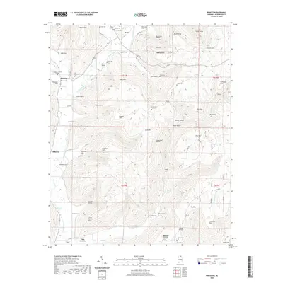
2020 Map of Princeton
USGS Topo · Published 2020About this map
Paint Rock River and its tributary Larkin Fork define the valley landscape of northern Jackson County. Small agricultural communities and family settlements like Princeton, Swaim, and Baileytown are nestled at the base of the Cumberland Plateau, which rises sharply to the east. The map records a dense distribution of local history markers, particularly family and community burial grounds such as Taliaferro-Clay Cem, Carden Cem, and the uniquely named Indian Grave Pond Cem. The rugged topography is etched with numerous hollows and points, including Black Gum Hollow and Bouldin Point, while the southern reaches of the quadrangle transition toward Skyline and Pleasant Groves. The winding ascent of the Winding Stairs near Sampson Point illustrates the historic difficulty of traversing the plateau's steep escarpments between the river valleys and the upland heights of Jacobs Mtn.
Find a feature on this map
104 named features on this map. Tap any name to fly to it.
Don’t see what you’re looking for? This feature index may not catch every label — zoom into the map to look around manually.
Map Details
Editions of this 2020 Princeton Map
This is the sole edition of this map. No revisions or reprints were ever made.
Other maps of this area

1888 · Scottsboro
USGS Topo · 1:125,000

1892 · Scottsboro
USGS Topo · 1:125,000

1936 · Scottsboro
USGS Topo · 1:24,000

1936 · King Cove
USGS Topo · 1:24,000

1936 · Hollytree
USGS Topo · 1:24,000

1936 · Mud Creek
USGS Topo · 1:24,000

1936 · Hytop
USGS Topo · 1:24,000

1936 · Princeton
USGS Topo · 1:24,000

1936 · Lim Rock
USGS Topo · 1:24,000
1936 · Paint Rock
USGS Topo · 1:24,000