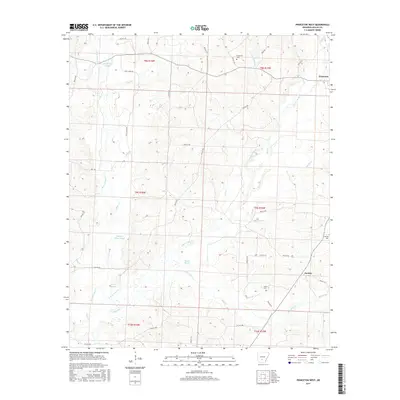
2017 Map of Princeton West
USGS Topo · Published 2017About this map
Princeton and Jacinto anchor this landscape in Dallas County, where the creek systems of the Ouachita River basin dictate the local geography. The area is defined by a dense network of slow-moving water and wetlands, including Alsobrook Slough, Hickory Flats Slough, and Black Slough, which weave through the timberlands. These drainages, such as W Fork Tulip Cr and White Oak Cr, historically shaped the settlement patterns and road placements in this part of Arkansas. Local heritage is preserved in several small burial grounds scattered across the terrain, notably Henderson Cem near the northern boundary and Taylor Cem further south. The map provides a clear view of the rural infrastructure, from the path of Hall Creek Rd to the various branches like Futch Br and Cooker Br that feed the larger tulip-named tributaries.
Find a feature on this map
35 named features on this map. Tap any name to fly to it.
Don’t see what you’re looking for? This feature index may not catch every label — zoom into the map to look around manually.
Map Details
Editions of this 2017 Princeton West Map
This is the sole edition of this map. No revisions or reprints were ever made.
Other maps of this area

1903 · Camden
USGS Topo · 1:125,000

1953 · El Dorado
USGS Topo · 1:250,000

1955 · Little Rock
USGS Topo · 1:250,000

1956 · Little Rock
USGS Topo · 1:250,000

1957 · El Dorado
USGS Topo · 1:250,000

1958 · El Dorado
USGS Topo · 1:250,000

1960 · El Dorado
USGS Topo · 1:250,000

1960 · Little Rock
USGS Topo · 1:250,000

1964 · Little Rock
USGS Topo · 1:250,000
1965 · Manning
USGS Topo · 1:24,000