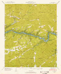
1940 Map of Proctor
USGS Topo · Published 1958About this map
The Proctor settlement and the CCC Camp NCNP 23 anchor the northern reaches of this landscape where the Great Smoky Mountains National Park meets the Nantahala National Forest. Recorded in 1940, the geography is defined by the transformation of the Little Tennessee River into Fontana Lake, with blue stippling indicating the areas soon to be submerged. This transitional moment captures the valley before the full impoundment of the water, showing the path of the Southern railroad and communities like Marcus, Wayside, and Dorsey along the river banks.
Find a feature on this map
129 named features on this map. Tap any name to fly to it.
Don’t see what you’re looking for? This feature index may not catch every label — zoom into the map to look around manually.
Map Details
Editions of this 1940 Proctor Map
This is the sole edition of this map. No revisions or reprints were ever made.
Other maps of this area

1886 · Knoxville
USGS Topo · 1:125,000

1892 · Knoxville
USGS Topo · 1:125,000

1894 · Knoxville
USGS Topo · 1:125,000

1895 · Knoxville
USGS Topo · 1:125,000

1901 · Knoxville
USGS Topo · 1:125,000

1933 · Bushnell
USGS Topo · 1:62,500

1935 · Robbinsville
USGS Topo · 1:24,000

1935 · Fontana
USGS Topo · 1:24,000

1936 · Proctor
USGS Topo · 1:24,000

1936 · Wesser
USGS Topo · 1:24,000