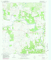
1966 Map of Proffitt
USGS Topo · Published 1982About this map
The Brazos River carves a winding path through this portion of Young County, defining the fertile lowlands of Johnson Bottom and the steep elevation of Deer Head Bluff. The landscape is a study in Texas resource extraction and transit history, marked by an extensive Oil Field in the northeast and scattered Oil Wells throughout the southern hills. Transportation patterns are anchored by an Old Railroad Grade running north toward Newcastle, showing the infrastructure of an earlier industrial era. In the west, the small community of Proffitt serves as a local hub near Proffitt Cem, while Woolfolk Cem sits further east near the river's bend. This 1966 survey, with 1981 revisions, documents the rural transition of north-central Texas, where family cemeteries and old cattle-country landmarks like Round Mound persist alongside the modern developments of the petroleum industry and a municipal Sewage Disposal site.
Find a feature on this map
29 named features on this map. Tap any name to fly to it.
Don’t see what you’re looking for? This feature index may not catch every label — zoom into the map to look around manually.
Map Details
Editions of this 1966 Proffitt Map
2 editions found
Other maps of this area

1925 · Graham 4-c
USGS Topo · 1:48,000

1927 · Graham
USGS Topo · 1:62,500

1954 · Wichita Falls
USGS Topo · 1:250,000

1958 · Wichita Falls
USGS Topo · 1:250,000

1964 · Newcastle
USGS Topo · 1:24,000

1964 · Padgett
USGS Topo · 1:24,000

1964 · True
USGS Topo · 1:24,000

1964 · Olney
USGS Topo · 1:24,000
1966 · Proffitt
USGS Topo · 1:24,000
1966 · Tackett Mountain
USGS Topo · 1:24,000