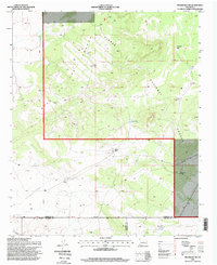
1995 Map of Progresso SW
USGS Topo · Published 1998About this map
Cibola National Forest encompasses the high country of this central New Mexico landscape, dominated by the expansive Mesa de los Jumanos. This 1995 survey illustrates a remote ranching environment where life and industry revolve entirely around scarce water sources. The map records a dense network of specialized improvements, including the Mesa Trick Tank, Horse Pasture Tank, and various family-named features like Atkinson Well and Dempster Well. To the south, the terrain descends into Atkinson Flats, where the Atkinson Ranch and Middle Well stand as primary landmarks of local habitation. The intersection of Torrance, Socorro, and Lincoln counties near the southern map boundary highlights the jurisdictional complexity of these rural grazing lands, while a single Pipeline crossing the southwestern corner represents the modern industrial footprint in an otherwise traditional western pastoral setting.
Find a feature on this map
19 named features on this map. Tap any name to fly to it.
Don’t see what you’re looking for? This feature index may not catch every label — zoom into the map to look around manually.
Map Details
Editions of this 1995 Progresso SW Map
This is the sole edition of this map. No revisions or reprints were ever made.
Other maps of this area

1954 · Fort Sumner
USGS Topo · 1:250,000

1954 · Socorro
USGS Topo · 1:250,000

1958 · Socorro
USGS Topo · 1:250,000

1958 · Fort Sumner
USGS Topo · 1:250,000

1962 · Socorro
USGS Topo · 1:250,000

1972 · Gran Quivira
USGS Topo · 1:24,000
1972 · Turkey Ridge NE
USGS Topo · 1:24,000
1972 · Round Top
USGS Topo · 1:24,000
1979 · Socorro
USGS Topo · 1:100,000

1980 · Corona
USGS Topo · 1:100,000