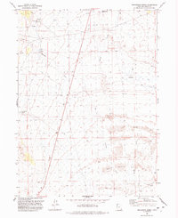
1991 Map of Prohibition Spring
USGS Topo · Published 1992About this map
Terrace (Site) anchors the southeastern corner of this map, reflecting a remote desert outpost in Box Elder County. Historically significant for its connection to the transcontinental railroad era, the location is marked here by the Terrace Cem and a nearby Terrace Well, indicating the critical need for water infrastructure in this arid environment. To the north, Rosebud Creek and Muddy Creek wind through a landscape defined by Alkali Flats and Sand Dunes.
Find a feature on this map
22 named features on this map. Tap any name to fly to it.
Don’t see what you’re looking for? This feature index may not catch every label — zoom into the map to look around manually.
Map Details
Editions of this 1991 Prohibition Spring Map
This is the sole edition of this map. No revisions or reprints were ever made.
Other maps of this area

1954 · Brigham City
USGS Topo · 1:250,000

1958 · Brigham City
USGS Topo · 1:250,000

1962 · Brigham City
USGS Topo · 1:250,000

1971 · Prohibition Spring
USGS Topo · 1:24,000

1971 · Emigrant Pass
USGS Topo · 1:24,000

1971 · Potters Creek
USGS Topo · 1:24,000

1971 · Red Dome
USGS Topo · 1:24,000
1971 · Runswick Wash
USGS Topo · 1:24,000

1971 · Warm Spring Hills
USGS Topo · 1:24,000

1983 · Terrace Mountain West
USGS Topo · 1:24,000