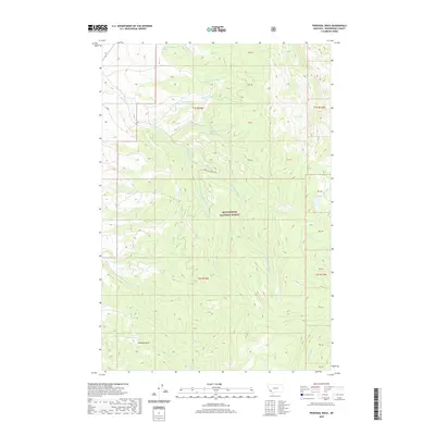
2020 Map of Proposal Rock
USGS Topo · Published 2020About this map
Proposal Rock stands as a prominent landmark in this high-altitude landscape within the Beaverhead National Forest. This 2020 survey records a complex hydrological network defined by the drainage systems of Doolittle Creek and its various branches, including the North Fork Doolittle Fork Creek and South Fork Doolittle Creek. The geography is further characterized by isolated water bodies like Lily Lake and Stone Lakes, alongside several numbered spring locations such as 01S14W22CABA01 Spring. The presence of Doolittle Creek Rd provides the primary transit corridor through this remote Montana terrain. This map serves as an essential reference for understanding the modern conservation and topography of Beaverhead County, documenting the specific locations of creeks like Demijohn Creek and McVey Creek that feed the region's larger watersheds.
Find a feature on this map
32 named features on this map. Tap any name to fly to it.
Don’t see what you’re looking for? This feature index may not catch every label — zoom into the map to look around manually.
Map Details
Editions of this 2020 Proposal Rock Map
This is the sole edition of this map. No revisions or reprints were ever made.
Other maps of this area

1955 · Dillon
USGS Topo · 1:250,000

1957 · Dillon
USGS Topo · 1:250,000

1958 · Dillon
USGS Topo · 1:250,000

1962 · Dillon
USGS Topo · 1:250,000

1962 · Wisdom
USGS Topo · 1:24,000

1962 · Mud Lake
USGS Topo · 1:24,000

1962 · Pine Hill
USGS Topo · 1:24,000

1962 · Stewart Mountain
USGS Topo · 1:24,000
1962 · Foolhen Mountain
USGS Topo · 1:24,000

1962 · Pintlar Lake
USGS Topo · 1:24,000