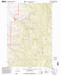
1997 Map of Proposal Rock
USGS Topo · Published 2002About this map
The Beaverhead National Forest defines this high-elevation landscape, where the headwaters of several major drainages converge. In this 1997 revision of a earlier survey, the complex hydrology of the region is mapped in detail, featuring the North Fork, Middle Fork, and South Fork as they carve through the mountain terrain. Notable landmarks like the namesake Proposal Rock stand out among the contours, while high-mountain waters such as Stone Lake and Lily Lake offer clear focal points for the landscape. The inclusion of the Pioneer Loop National Recreation Trail and boundaries for the Wisdom Ranger District reflects the land's transition into a managed wilderness and recreation area during the late twentieth century. This map traces the established trails and forest service access points that provided entry into the backcountry during this era.
Find a feature on this map
15 named features on this map. Tap any name to fly to it.
Don’t see what you’re looking for? This feature index may not catch every label — zoom into the map to look around manually.
Map Details
Editions of this 1997 Proposal Rock Map
This is the sole edition of this map. No revisions or reprints were ever made.
Other maps of this area

1955 · Dillon
USGS Topo · 1:250,000

1957 · Dillon
USGS Topo · 1:250,000

1958 · Dillon
USGS Topo · 1:250,000

1962 · Dillon
USGS Topo · 1:250,000

1962 · Wisdom
USGS Topo · 1:24,000

1962 · Mud Lake
USGS Topo · 1:24,000

1962 · Pine Hill
USGS Topo · 1:24,000

1962 · Stewart Mountain
USGS Topo · 1:24,000
1962 · Foolhen Mountain
USGS Topo · 1:24,000

1962 · Pintlar Lake
USGS Topo · 1:24,000