
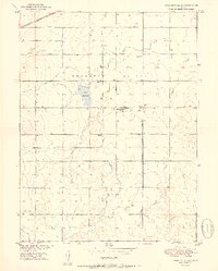
1951 Map of Prospect Valley
USGS Topo · Published 1951About this map
Prospect Valley is characterized by an extensive network of irrigation ditches and canals supporting agriculture along the Chicago Burlington and Quincy railroad line. At the time of this 1950 topography survey, the landscape is dotted with numerous small settlements and family-named locations such as Krauss, Johnson, Sheehan, and Sloan. The presence of the USBR Prospect Valley Sub Station and the Prospect Valley School suggests a community organized around centralized services and water management. Water features like Lord Reservoir and the Henrylyn Canal dominate the terrain, illustrating the intensive engineering required to sustain farming in this part of Weld County. The map also delineates the boundary between Weld Co and Adams Co at its southern edge, providing a clear record of local jurisdictional lines during the mid-century development of the Missouri River Basin.
Find a feature on this map
20 named features on this map. Tap any name to fly to it.
Don’t see what you’re looking for? This feature index may not catch every label — zoom into the map to look around manually.
Map Details
Editions of this 1951 Prospect Valley Map
2 editions found
Other maps of this area

1890 · East Denver
USGS Topo · 1:125,000

1902 · Greeley
USGS Topo · 1:125,000

1949 · Sunnydale
USGS Topo · 1:24,000

1950 · South Roggen
USGS Topo · 1:24,000

1950 · Tampa
USGS Topo · 1:24,000

1950 · Keenesburg
USGS Topo · 1:24,000

1950 · Prospect Valley
USGS Topo · 1:24,000

1950 · Klug Ranch
USGS Topo · 1:24,000

1951 · Keenesburg
USGS Topo · 1:24,000
1951 · Klug Ranch
USGS Topo · 1:24,000