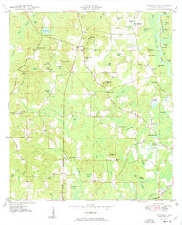
1950 Map of Prosperity
USGS Topo · Published 1950About this map
The Arrant Settlement and Baker Settlement are prominent features in this 1950 survey of Holmes County, Florida, illustrating the rural family-centric land patterns of the mid-century. The landscape is a dense network of water bodies and hills, from Andrews Lake in the northwest to the numerous sand ponds like Hood Sand Pond and Little Sand Pond in the southeast. Transportation is anchored by the Louisville and Nashville Railroad and the Old Spanish Trail crossing the lower corner of the sheet. Religious and educational centers such as Cedar Springs Sch, Hudson Hill Ch, and Otter Creek Ch appear as vital community hubs. Several named hills, including Nancy Padgett Hill and Bunker Hill, provide topographic context to this area defined by its numerous "bays" and creek systems.
Find a feature on this map
87 named features on this map. Tap any name to fly to it.
Don’t see what you’re looking for? This feature index may not catch every label — zoom into the map to look around manually.
Map Details
Editions of this 1950 Prosperity Map
3 editions found
Other maps of this area

1935 · De Funiak Springs
USGS Topo · 1:48,000

1938 · De Funiak Springs
USGS Topo · 1:62,500

1948 · Ponce De Leon
USGS Topo · 1:24,000

1949 · Glendale
USGS Topo · 1:62,500

1949 · Hinsons Cross Roads
USGS Topo · 1:24,000

1949 · Hobbs Crossroads
USGS Topo · 1:24,000

1949 · Caryville
USGS Topo · 1:24,000

1950 · Hobbs Cross Roads
USGS Topo · 1:24,000

1950 · Prosperity
USGS Topo · 1:24,000

1950 · Ponce De Leon
USGS Topo · 1:24,000