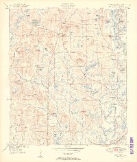
1950 Map of Prosperity
USGS Topo · Published 1950About this map
Arrant Settlement and Baker Settlement anchor this 1949 topographic study of Holmes County, Florida, where scattered farmsteads and rural community centers define the landscape. The geography is dominated by a dense network of swampy depressions and bays, such as Blackman Swamp and Panther Bay, which dictate the winding paths of local roads. In the eastern corridor, the Choctawhatchee River creates a labyrinth of oxbows and islands, including Bearpen Bend and Horseshoe Lake.
Find a feature on this map
86 named features on this map. Tap any name to fly to it.
Don’t see what you’re looking for? This feature index may not catch every label — zoom into the map to look around manually.
Map Details
Editions of this 1950 Prosperity Map
3 editions found
Other maps of this area

1935 · De Funiak Springs
USGS Topo · 1:48,000

1938 · De Funiak Springs
USGS Topo · 1:62,500

1948 · Ponce De Leon
USGS Topo · 1:24,000

1949 · Glendale
USGS Topo · 1:62,500

1949 · Hinsons Cross Roads
USGS Topo · 1:24,000

1949 · Hobbs Crossroads
USGS Topo · 1:24,000

1949 · Caryville
USGS Topo · 1:24,000

1950 · Hobbs Cross Roads
USGS Topo · 1:24,000

1950 · Prosperity
USGS Topo · 1:24,000

1950 · Ponce De Leon
USGS Topo · 1:24,000