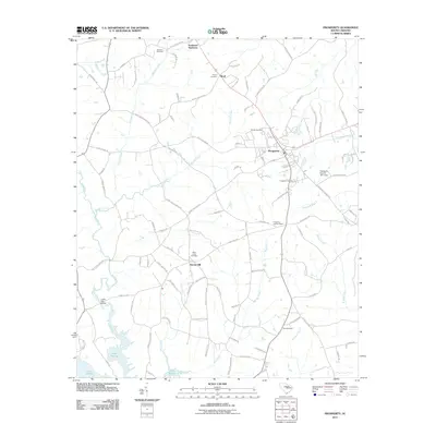
2011 Map of Prosperity
USGS Topo · Published 2011About this map
Prosperity stands as the central hub of this Newberry County landscape, where the convergence of regional roads and local streets like Glenn St and Church St defines the town's grid. The geography is characterized by the intricate drainage systems of Camping Creek, Timothy Creek, and the Bush River, which feed southward toward the expansive waters of Lake Murray. This lakefront development in the south contrasts with the agricultural and residential clusters found at Stoney Hill and Boyd to the north.
Find a feature on this map
99 named features on this map. Tap any name to fly to it.
Don’t see what you’re looking for? This feature index may not catch every label — zoom into the map to look around manually.
Map Details
Editions of this 2011 Prosperity Map
This is the sole edition of this map. No revisions or reprints were ever made.
Other maps of this area

1904 · Columbia
USGS Topo · 1:125,000

1941 · Spartanburg
USGS Topo · 1:250,000

1953 · Spartanburg
USGS Topo · 1:250,000

1960 · Spartanburg
USGS Topo · 1:250,000

1963 · Spartanburg
USGS Topo · 1:250,000

1964 · Spartanburg
USGS Topo · 1:250,000

1968 · Newberry East
USGS Topo · 1:24,000

1969 · Pomaria
USGS Topo · 1:24,000

1969 · Newberry West
USGS Topo · 1:24,000
1970 · Prosperity
USGS Topo · 1:24,000