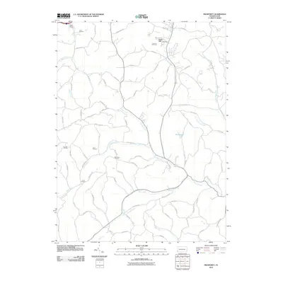
2010 Map of Prosperity
USGS Topo · Published 2010About this map
Tenmile Creek and its winding tributaries, including Crafts Creek and Short Creek, carve through the agricultural landscape of Washington County in this 2010 survey. This area of East Finley Township is defined by its rural cemetery network, which serves as a vital record for family researchers. Notable sites include South Buffalo Cemetery, Fairview Cemetery, and Mount Zion Cemetery, often situated on the high ridges between drainage basins like Sawhill Run and Hamestring Run.
Find a feature on this map
86 named features on this map. Tap any name to fly to it.
Don’t see what you’re looking for? This feature index may not catch every label — zoom into the map to look around manually.
Map Details
Editions of this 2010 Prosperity Map
This is the sole edition of this map. No revisions or reprints were ever made.
Other maps of this area

1901 · Amity
USGS Topo · 1:62,500

1901 · Waynesburg
USGS Topo · 1:62,500

1904 · Amity
USGS Topo · 1:62,500

1904 · Waynesburg
USGS Topo · 1:62,500

1905 · Rogersville
USGS Topo · 1:62,500

1907 · Claysville
USGS Topo · 1:62,500

1949 · Clarksburg
USGS Topo · 1:250,000

1951 · Canton
USGS Topo · 1:250,000

1953 · Canton
USGS Topo · 1:250,000
1953 · Washington East
USGS Topo · 1:24,000
Featured Places
- East Finley Township, PA
- Green Hills, PA
- Point Lookout, South Franklin Township
- Sparta, Morris Township
- Gale, East Finley Township