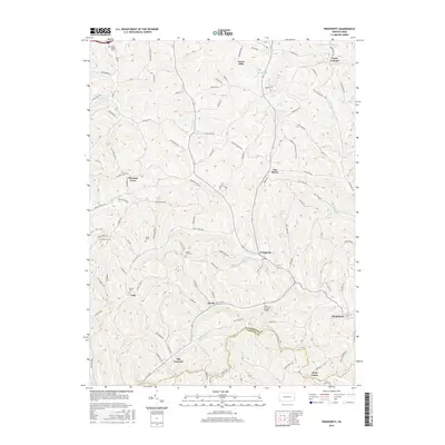
2016 Map of Prosperity
USGS Topo · Published 2016About this map
Tenmile Creek and its many tributaries, including Templeton Fork and Bates Fork, carve through the high ridges of Washington and Greene Counties. This 2016 survey shows a landscape defined by small rural settlements and a dense network of family-named roads like Mounts Road and Highland Ridge Road. The area around Prosperity and Old Concord is dotted with several significant burial grounds, including Fairview Cemetery and Mount Zion Cemetery, which serve as vital markers for local genealogical research.
Find a feature on this map
103 named features on this map. Tap any name to fly to it.
Don’t see what you’re looking for? This feature index may not catch every label — zoom into the map to look around manually.
Map Details
Editions of this 2016 Prosperity Map
This is the sole edition of this map. No revisions or reprints were ever made.
Other maps of this area

1901 · Amity
USGS Topo · 1:62,500

1901 · Waynesburg
USGS Topo · 1:62,500

1904 · Amity
USGS Topo · 1:62,500

1904 · Waynesburg
USGS Topo · 1:62,500

1905 · Rogersville
USGS Topo · 1:62,500

1907 · Claysville
USGS Topo · 1:62,500

1949 · Clarksburg
USGS Topo · 1:250,000

1951 · Canton
USGS Topo · 1:250,000

1953 · Canton
USGS Topo · 1:250,000
1953 · Washington East
USGS Topo · 1:24,000
Featured Places
- East Finley Township, PA
- Green Hills, PA
- Point Lookout, South Franklin Township
- Sparta, Morris Township
- Gale, East Finley Township