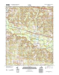
2013 Map of Providence Forge
USGS Topo · Published 2013About this map
Providence Forge sits at the heart of this landscape, where the Chickahominy River creates a complex network of wetlands and tributaries. The area's history is tied to these waters, with Old Forge Pond and Oldhouse Landing marking historical points of transit and industry. The terrain transitions from the higher elevations of Minitree Hill down to significant marshlands like Rumley Marsh and Big Swamp.
Find a feature on this map
70 named features on this map. Tap any name to fly to it.
Don’t see what you’re looking for? This feature index may not catch every label — zoom into the map to look around manually.
Map Details
Editions of this 2013 Providence Forge Map
This is the sole edition of this map. No revisions or reprints were ever made.
Other maps of this area

1917 · Toano
USGS Topo · 1:62,500

1918 · Charles City
USGS Topo · 1:62,500

1918 · Toano
USGS Topo · 1:62,500

1919 · New Kent
USGS Topo · 1:62,500

1920 · King William
USGS Topo · 1:62,500

1943 · Richmond
USGS Topo · 1:250,000
1949 · Quinton
USGS Topo · 1:24,000

1949 · Tunstall
USGS Topo · 1:24,000

1949 · New Kent
USGS Topo · 1:24,000

1949 · Richmond
USGS Topo · 1:250,000