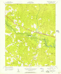
1953 Map of Providence Forge
USGS Topo · Published 1957About this map
The Chickahominy River winds through the heart of this coastal Virginia landscape, forming the natural boundary between New Kent and Charles City counties. The mid-century topography reveals a community structured around the Chesapeake and Ohio railroad line and the Pocahontas Trail, where the hub of Providence Forge serves as a primary settlement. To the west, the village of Mountcastle is anchored by its namesake Mountcastle Sch, while the rural interior is dotted with small family-named crossroads like Roaches Corner and Binns Store.
Find a feature on this map
59 named features on this map. Tap any name to fly to it.
Don’t see what you’re looking for? This feature index may not catch every label — zoom into the map to look around manually.
Map Details
Editions of this 1953 Providence Forge Map
This is the sole edition of this map. No revisions or reprints were ever made.
Other maps of this area

1917 · Toano
USGS Topo · 1:62,500

1918 · Charles City
USGS Topo · 1:62,500

1918 · Toano
USGS Topo · 1:62,500

1919 · New Kent
USGS Topo · 1:62,500

1920 · King William
USGS Topo · 1:62,500

1943 · Richmond
USGS Topo · 1:250,000
1949 · Quinton
USGS Topo · 1:24,000

1949 · Tunstall
USGS Topo · 1:24,000

1949 · New Kent
USGS Topo · 1:24,000

1949 · Richmond
USGS Topo · 1:250,000