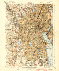
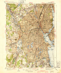
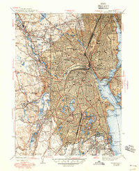
1939 Map of Providence
USGS Topo · Published 1939About this map
The industrial and institutional heart of Rhode Island is captured here in the late 1930s, centered on the dense urban core of Providence and expanding into the mill towns and residential suburbs of Cranston and North Providence. The Woonasquatucket River and Providence River serve as the city's lifelines, lined with infrastructure like the Wilkes Barre Pier and State Pier. Educational and civic life is anchored by prominent campuses including Brown University, Providence College, and the State Capitol.
Find a feature on this map
141 named features on this map. Tap any name to fly to it.
Don’t see what you’re looking for? This feature index may not catch every label — zoom into the map to look around manually.
Map Details
Editions of this 1939 Providence Map
3 editions found
Other maps of this area

1887 · Providence
USGS Topo · 1:62,500

1889 · Providence
USGS Topo · 1:62,500

1889 · Burrillville
USGS Topo · 1:62,500

1890 · Narragansett Bay
USGS Topo · 1:62,500

1890 · Kent
USGS Topo · 1:62,500

1892 · Narragansett Bay
USGS Topo · 1:62,500

1894 · Burrillville
USGS Topo · 1:62,500

1894 · Kent
USGS Topo · 1:62,500

1894 · Providence
USGS Topo · 1:62,500

1915 · Burrillville
USGS Topo · 1:62,500