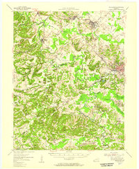
1954 Map of Providence
USGS Topo · Published 1957About this map
Providence serves as the industrial and social anchor of this Western Kentucky landscape during the mid-1950s, a period defined by the convergence of heavy rail and extractive industry. The Illinois Central Railroad and Louisville & Nashville Railroad cut through the terrain, connecting coal operations like the Stony Point Mines and various Strip Mines to wider markets. The map reveals a deeply etched topography where names like Black Rough Bottom and Carding Machine Hill suggest a history of both difficult land and early local manufacturing.
Find a feature on this map
134 named features on this map. Tap any name to fly to it.
Don’t see what you’re looking for? This feature index may not catch every label — zoom into the map to look around manually.
Map Details
Editions of this 1954 Providence Map
This is the sole edition of this map. No revisions or reprints were ever made.
Other maps of this area

1906 · Sebree
USGS Topo · 1:62,500

1907 · Earlington
USGS Topo · 1:48,000

1907 · Morganfield
USGS Topo · 1:62,500

1908 · Princeton
USGS Topo · 1:62,500

1909 · Dawson Springs
USGS Topo · 1:48,000

1909 · Earlington
USGS Topo · 1:62,500

1909 · Providence
USGS Topo · 1:62,500

1910 · Princeton
USGS Topo · 1:62,500

1911 · Dawson Springs
USGS Topo · 1:62,500

1916 · Shawneetown
USGS Topo · 1:62,500