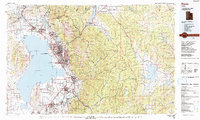
1986 Map of Provo
USGS Topo · Published 1986About this map
Provo and Orem serve as the urban anchor of this 1980s-era landscape, where the rapidly expanding settlements of the Utah Valley meet the towering Wasatch Range. The map documents the intricate water management system vital to the region, featuring large-scale works like Deer Creek Reservoir and Strawberry Reservoir, alongside the massive expanse of Utah Lake. The transport network is dominated by the Denver and Rio Grande Western RR and Union Pacific RR, which parallel the major road corridors of I-15 and U S 89.
Find a feature on this map
66 named features on this map. Tap any name to fly to it.
Don’t see what you’re looking for? This feature index may not catch every label — zoom into the map to look around manually.
Map Details
Editions of this 1986 Provo Map
This is the sole edition of this map. No revisions or reprints were ever made.
Other maps of this area

1885 · Salt Lake
USGS Topo · 1:250,000

1885 · Manti
USGS Topo · 1:250,000

1885 · Sevier Desert
USGS Topo · 1:250,000

1885 · Uinta
USGS Topo · 1:250,000

1885 · Tooele Valley
USGS Topo · 1:250,000

1886 · Price River
USGS Topo · 1:250,000

1895 · Manti
USGS Topo · 1:250,000

1896 · Price River
USGS Topo · 1:250,000

1900 · Coalville
USGS Topo · 1:125,000

1901 · Hayden Peak
USGS Topo · 1:125,000