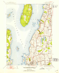
1939 Map of Prudence Island
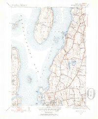
USGS Topo · Published 1953About this map
Prudence Island sits at the heart of this survey, flanked by the East Passage and the broader waters of Narragansett Bay. The landscape of the late 1930s is defined by a mix of maritime infrastructure and rural estates, with the northern reaches of Newport and the rolling terrain of Middletown and Portsmouth showing a dense network of local lanes like Wapping Rd and Green End Ave. Military and institutional presence is prominent, evidenced by the US Naval Reservation and US Naval Hospital near the coast.
Find a feature on this map
105 named features on this map. Tap any name to fly to it.
Don’t see what you’re looking for? This feature index may not catch every label — zoom into the map to look around manually.
Map Details
Editions of this 1939 Prudence Island Map
2 editions found
Other maps of this area

1885 · Sakonnet
USGS Topo · 1:62,500

1888 · Fall River
USGS Topo · 1:62,500

1888 · Sakonnet
USGS Topo · 1:62,500

1889 · Newport
USGS Topo · 1:62,500

1890 · Narragansett Bay
USGS Topo · 1:62,500

1892 · Narragansett Bay
USGS Topo · 1:62,500

1893 · Sakonnet
USGS Topo · 1:62,500

1893 · Fall River
USGS Topo · 1:62,500

1894 · Newport
USGS Topo · 1:62,500

1904 · Newport
USGS Topo · 1:62,500