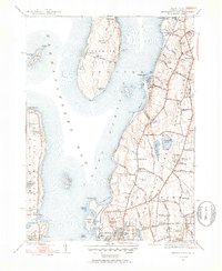
1939 Map of Prudence Island
USGS Topo · Published 1953About this map
Narragansett Bay dominates this late-1930s survey, illustrating the maritime and military character of Newport County before mid-century development. The land is divided between the rural interior of Prudence and the more densely settled coastal strips of Middletown and South Portsmouth. Military activity is prominent along the shorelines, from the US Naval Reservation and US Naval Hospital to historical fortifications like Fort Butts. The map reveals a landscape still largely defined by its early institutional foundations, featuring numerous local schools such as Coggeshall Sch and Oliphant Sch, alongside the landmark Whitehall estate. Transportation relies on the New Haven and Hartford RR and a network of named lanes like Braman Lane and Wyatt Road, while the island of Prudence remains largely undeveloped, characterized by features like Schoolhouse Swamp and the small settlement at Homestead.
Find a feature on this map
96 named features on this map. Tap any name to fly to it.
Don’t see what you’re looking for? This feature index may not catch every label — zoom into the map to look around manually.
Map Details
Editions of this 1939 Prudence Island Map
2 editions found
Other maps of this area

1885 · Sakonnet
USGS Topo · 1:62,500

1888 · Fall River
USGS Topo · 1:62,500

1888 · Sakonnet
USGS Topo · 1:62,500

1889 · Newport
USGS Topo · 1:62,500

1890 · Narragansett Bay
USGS Topo · 1:62,500

1892 · Narragansett Bay
USGS Topo · 1:62,500

1893 · Sakonnet
USGS Topo · 1:62,500

1893 · Fall River
USGS Topo · 1:62,500

1894 · Newport
USGS Topo · 1:62,500

1904 · Newport
USGS Topo · 1:62,500