
1963 Map of Prudenville
USGS Topo · Published 1964About this map
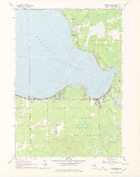
Houghton Lake dominates this mid-century portrait of Roscommon County, its expansive shoreline defining the settlement patterns of Prudenville and the surrounding woodlands. The map captures a period of recreational and civic growth, evidenced by the dense grid of vacation properties and year-round residences along East Bay and the northern reaches of the Houghton Lake State Forest. Local infrastructure is well-detailed, from the Roscommon County Airfield near Markey Park to the institutional foundations of the community at the Houghton Lake High Sch and the North Shore Sch.
Find a feature on this map
24 named features on this map. Tap any name to fly to it.
Don’t see what you’re looking for? This feature index may not catch every label — zoom into the map to look around manually.
Map Details
Editions of this 1963 Prudenville Map
2 editions found
Other maps of this area

1954 · Traverse City
USGS Topo · 1:250,000

1956 · Houghton Lake
USGS Topo · 1:62,500

1957 · Harrison
USGS Topo · 1:62,500

1958 · Traverse City
USGS Topo · 1:250,000

1963 · Roscommon South
USGS Topo · 1:24,000

1963 · Backus Lake
USGS Topo · 1:24,000
1963 · Lyon Manor
USGS Topo · 1:24,000

1969 · Meredith NW
USGS Topo · 1:24,000

1969 · Meredith
USGS Topo · 1:24,000
1983 · Meads Landing
USGS Topo · 1:25,000